HomeTestsSearchRankProfile

Indian Geography Questions

Practice 319 Indian Geography questions with detailed answers and explanations. Free MCQs, PYQs, and mock test questions for NEET, JEE, GATE, SSC and more.

📚
319
Total Questions
🟢
6
Easy
🟡
313
Medium
🔴
0
Hard

About Indian Geography — practice questions, PYQs & concepts

Indian Geography is a frequently-tested topic on Geography, General Studies, General Knowledge. ExamTest.live currently lists 319 Indian Geography questions spanning previous-year papers from 2016 to 2026, each with worked solutions and a step-by-step explanation. Use the filters on this page to focus on a specific exam, difficulty level or year — every answer key is free, no sign-up required.

Indian Geography weight in competitive exams

Across our Indian Geography question bank, the largest sources are Geography (187), General Studies (39), General Knowledge (30), General Awareness (24) and History & Geography of India (17). Click any exam chip above to drill down to that exam-specific question set.

How to use this page

  • Start easy: 6 easy Indian Geography questions are available — build fluency before moving up.
  • Target weak years: Use the year filter to focus on the most recent 2026 paper or older PYQs you have not attempted.
  • Time yourself: Every question shows the average solve time so you can benchmark your speed against other students.
  • Read every explanation: Even on questions you got right — the explanation often surfaces a faster approach you can reuse.
All Indian Geography Questions(1100 of 319)

4 pages
Filter:
Q1mediummcqGeneral KnowledgeStaff Selection Commission2026
60% accuracy
Bhopal is the Capital City of _________.
Q2mediummcqGeographySSC CGL2026
25% accuracy
Which mineral found in the Koderma and Giridih districts of Jharkhand is used for power industry, paint and pigment industry etc.?
Q3mediummcqGeographySSC CGL2026
50% accuracy
Which is the most suitable soil for growing coffee in India?
Q4mediummcqGeographyCompetitive Exam Practice2026
0% accuracy
Himalayas are divided into:
Q5mediummcqGeneral AwarenessCompetitive Exam2026
0% accuracy
Which state in India is the source of river Ghaggar?
Q6mediummcqGeographySSC CGL2026
33% accuracy
Koderma Gaya Hazaribagh belt is known for the production of which of the following minerals?
Q7mediummcqGeneral AwarenessCompetitive Exam2026
0% accuracy
India is the second most populous country with a population of ______, according to the 2011 census data.
Q8mediummcqGeographyWest Bengal Civil Services2026
50% accuracy
Rohilkhand region lies in which of the following regions?
Q9mediummcqGeneral AwarenessSSC General Awareness2026
0% accuracy
West Bengal is bordered by all these countries except ______.
Q10mediummcqGeographySSC GD2026
0% accuracy
The major gap in the Western Ghats is at:
Q11mediummcqGeographyCompetitive Exams2026
50% accuracy
Which of the following states is the least populated according to census 2011?
Q12mediummcqGeographyWest Bengal Civil Services2026
0% accuracy
The mountain range lying between India and Myanmar is
Q13mediummcqGeographyWBCS Prelims 20182026
50% accuracy
The highest peak in India, is also known as
Q14mediummcqGeographyCompetitive Exam Practice Paper2026
50% accuracy
The Chotonagpur plateau is primarily composed of
Q15mediummcqGeneral StudiesWBCS Prelims2026
0% accuracy
In India, Karst landforms are formed in:
Q16mediummcqGeographyCompetitive Exams2026
0% accuracy
Which of the following rivers is NOT related to the coastal plain of India?
Q17mediummcqGeneral StudiesWBCS Prelims 20182026
0% accuracy
Under the old numbering system, the Kolkata-Mumbai National Highway via Agra is known as:
Q18mediummcqGeographyWBCS Prelims2026
50% accuracy
_____is the only active volcano in India.
Q19mediummcqGeneral AwarenessSSC CGL2026
50% accuracy
Nathu La pass is located in ________.
Q20mediummcqGeographyWBCS Prelims 20182026
0% accuracy
The Dongras inhabit mainly
Q21mediummcqGeographyWBCS Prelims2026
50% accuracy
Importance of Dolphin's nose at Vishakhapatnam is as:
Q22mediummcqGeneral StudiesWBCS Prelims2026
0% accuracy
The highest Peak in the Andaman Island is:
Q23mediummcqGeographyWest Bengal Civil Services2026
0% accuracy
In India, the second most populated district (Census 2011) is:
Q24mediummcqGeneral Knowledge and General AwarenessSSC CPO 20242026
0% accuracy
What is the average height of the Eastern Ghats of India?
Q25mediummcqGeographyWBCS Prelims2026
100% accuracy
Which of the following states has least population density, as per census ?
Q26mediummcqGeographyCompetitive Exam2026
0% accuracy
The Shillong Plateau is widely known as 'Meghalaya'. Who among the following geographers coined this term?
Q27mediummcqGeographySSC CGL2026
0% accuracy
India can be divided into how many physiographic regions?
Q28mediummcqGeographySSC CGL2026
0% accuracy
Inland streams which do NOT drain out into sea are generally found in which state of India?
Q29mediummcqGeographyCompetitive Exam Practice Paper2026
0% accuracy
Which one of the following states in India has higher percentage of tank irrigation?
Q30mediummcqGeographyCompetitive Exam2026
100% accuracy
The largest area under wasteland in India is in:
Q31mediummcqGeographyWBCS Prelims2026
0% accuracy
The biggest ship-building yard of India is
Q32mediummcqGeographySSC CGL2026
0% accuracy
Which of the following statements is/are INCORRECT?
A: Kuttanad is in the state of Karnataka.
B: Kuttanad Agriculture System favours rice cultivation below sea level.
C: Kuttanad is a Ramsar site and a reputed destination for water tourism.
Q33mediummcqGeneral StudiesWBCS Prelims 20152026
0% accuracy
Cotton is best grown on black lava soils called.
Q34mediummcqGeographyCompetitive Exam2026
0% accuracy
The Amarkantak Hill is the origin point of two major rivers that flow in completely different directions (West and East). These two rivers are:
Q35mediummcqGeographyCompetitive Exam2026
0% accuracy
Xerophytic vegetation is a characteristic feature of
Q36mediummcqGeographyCompetitive Exam2026
100% accuracy
The greatest potential for the generation of tidal power in India is available in the:
Q37mediummcqGeographyCompetitive Exam2026
0% accuracy
Which of the following rivers of India is an antecedent river that is older than the Himalayas?
Q38mediummcqGeneral AwarenessSSC CGL2026
0% accuracy
In January 2020, which of the following states obtained a Geographical Indication (GI) Tag for the popular ‘Khola Chillies’?
Q39mediummcqGeographyCompetitive Exam2026
100% accuracy
A person flying over India observed the natural vegetation below changing in the specific sequential order of tropical evergreen forest, savanna, dry deciduous, and deciduous. This flight path corresponds to a journey from:
Q40mediummcqGeographyMock Test2026
0% accuracy
Where does the Indus River drain into?
Q41mediummcqGeographySSC CGL2026
100% accuracy
Dehradun is the capital city of _________.
Q42mediummcqGeographyCompetitive Exam2026
100% accuracy
Which are the oldest mountains in India?
Q43mediummcqGeneral Knowledge and General AwarenessSSC CPO 20242026
0% accuracy
Which biosphere reserve in southern Andhra Pradesh is home to several endemic species, including the famous red sanders and slender loris?
Q44mediummcqGeographyCompetitive Exam2026
100% accuracy
Which one of the following mountain ranges features two distinctly dissimilar types of vegetation on its two opposing slopes due to the rain-shadow effect?
Q45mediummcqGeneral KnowledgeCompetitive Exam2026
0% accuracy
Which is the largest museum in India?
Q46mediummcqGeographyCompetitive Exam2026
0% accuracy
Which among the following is the most densely populated Indian state according to the 2011 census?
Q47mediummcqGeneral Knowledge and General AwarenessSSC CPO 20242026
0% accuracy
Which of the following mountain peaks is located in the Karakoram Range?
Q48mediummcqGeneral StudiesCompetitive Exam2026
100% accuracy
Which one of the following is the junction point of the Eastern Ghats and the Western Ghats?
Q49mediummcqGeographyCompetitive Exam Practice Paper2026
0% accuracy
The capital of West Bengal is located close to the:
Q50mediummcqGeographyPrepp2026
0% accuracy
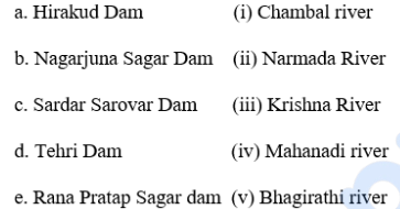
Match the following dams with the rivers on which they are constructed, based on the provided source
image
Q51mediummcqGeographyCompetitive Examination2026
0% accuracy
Which of the following towns is located on the bank of the Karola River?
Q52mediummcqGeographyWest Bengal Civil Services2026
0% accuracy
Petroleum Refineries in India mostly have
Q53mediummcqGeographyCompetitive Exam2026
0% accuracy
Which state is the leading milk producer in India?
Q54mediummcqGeneral Knowledge and General AwarenessSSC CPO 20242026
0% accuracy
Identify the crop grown in the Kharif crop season in the northern states of India.
Q55mediummcqGeographyGeneral Knowledge2026
0% accuracy
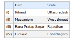
Consider the following pairs:


How many of the pairs given above is/are correctly matched?
Q56mediummcqGeographyIndian Competitive Exam Prep2026
0% accuracy
Which of the following mountain peaks does not geographically belong to the main Himalayan Range?
Q57mediummcqGeographyCompetitive Examination2026
0% accuracy
Which one of the following is not located in West Bengal?
Q58mediummcqGeneral KnowledgeCompetitive Exam2026
0% accuracy
Ellora is a sacred site situated in which of the following states, as questioned in image_66ceff.jpg?
Q59mediummcqGeographyWest Bengal Civil Services2026
0% accuracy
Tamil Nadu is the only state with more than one major port because
Q60mediummcqGeographyCompetitive Examination2026
0% accuracy
The boundary tectonic fault between the Greater and the Lesser Himalaya is known as the:
Q61mediummcqGeneral KnowledgeIndian Competitive Exam Prep2026
0% accuracy
Golden Quadrilateral is a
Q62mediummcqGeneral Knowledge and General AwarenessSSC CPO 20242026
0% accuracy
What is the total length of the Golden Quadrilateral highway network built by the National Highways Authority of India (NHAI)?
Q63mediummcqGeographyGeneral Knowledge2026
0% accuracy
Andaman and Nicobar Islands are separated by
Q64mediummcqGeographyCompetitive Exam Mock2026
0% accuracy
Consider the following pairs:

image

Which of the pairs given above is/are correctly matched?
Q65mediummcqGeographyGeneral Knowledge2026
0% accuracy
Which of the following Indian states does not share the boundary with West Bengal?
Q66mediummcqGeographySSC CGL2026
0% accuracy
Which of the following states does NOT share its border with Bangladesh?
Q67mediummcqGeneral StudiesWBCS Prelims 20152026
0% accuracy
In the 2001 census, Madhya Pradesh has been bifurcated into
Q68mediummcqGeographyCompetitive Exam Mock2026
0% accuracy
Which one of the following is not correctly matched?
Q69mediummcqGeographyCompetitive Examination2026
0% accuracy
Indian Topographical Map is published by
Q70mediummcqGeographyCompetitive Examination2026
0% accuracy
Dehradun is the capital city of Uttarakhand. What does ‘dun’ (also spelled ‘doon’) signify here?
Q71mediummcqEnvironmental ScienceCompetitive Exam2026
0% accuracy
Forest Cover in which State (s) have shown an increase in the last two years, according to Forest Survey of India?
Q72mediummcqGeographyWBCS Prelims2026
100% accuracy
The Indian Peninsula is surrounded by water on:
Q73mediummcqGeographyIndian Competitive Exam Prep2026
0% accuracy
The retreating South-West Monsoon brings rain in which part of India?
Q74mediummcqGeographyGovernment Competitive Exam2026
0% accuracy
Which separates the mainland of India from Rameswaram Island?
Q75mediummcqGeographySSC CGL2026
0% accuracy
Which city is located on the banks of the river Narmada?
Q76mediummcqGeneral AwarenessSSC CGL2026
0% accuracy
Pipli Ghat Pass is located in which mountain area?
Q77mediummcqGeographyPrepp2026
Choose the correct statements about the islands of India.
a. Lakshadweep Islands are composed of coral islands.
b. Andaman and Nicobar islands are composed of coral islands.
c. It is believed that Lakshadweep islands are an elevated portion of submarine mountains.
d. It is believed that Andaman and Nicobar islands are an elevated portion of submarine mountains.
Q78mediummcqGeneral AwarenessPractice Paper2026
Which of the following Indian states shares a border with both Myanmar and Bhutan?
Q79mediummcqGeographySSC CGL2026
The Indus river that originates in the northern slopes of the Kailash range in Tibet, enters Indian territory in which of the following states or union territories?
Q80mediummcqGeneral Knowledge and General AwarenessPrepp2026
Which of the following mountain peaks is located in the Karakoram Range?
Q81mediummcqGeneral AwarenessStaff Selection Commission2026
Which of the following is true about sex ratio in India during 1951 - 2011?
Q82mediummcqGeneral KnowledgeIndian Competitive Exams2026
India shares the Lipulekh Pass with which country?
Q83mediummcqGeographySSC CGL2026
What is another name for Bardoli Chheerha?
Q84mediummcqGeneral AwarenessStaff Selection Commission2026
When was the Border Road Organisation established in India?
Q85mediummcqGeographySSC CGL2026
Select the natural port of India from the following.
Q86mediummcqEnvironment and EcologyCompetitive Exam2026
Which of the following states has the Ramsar Wetland site named ‘Deepor Beel’?
Q87mediummcqGeneral AwarenessGovernment Exams2026
Through which of the following states does the river Brahmaputra NOT flow?
Q88mediummcqGeneral Knowledge and General AwarenessPrepp2026
Which biosphere reserve of Southern Andhra Pradesh is home to many endemic species including the famous Red Sanders and Slender Loris?
Q89mediummcqGeneral AwarenessStaff Selection Commission2026
'Bibi ka Maqbara' at Aurangabad is situated in which of the following states of India?
Q90mediummcqGeographyCompetitive Exam2026
With which of the following states does Bihar NOT share its borders?
Q91mediummcqGeneral AwarenessStaff Selection Commission2026
What was the growth rate of India's population in the decade of 2001 - 2011?
Q92mediummcqGeographySSC CGL2026
Which of the following rivers has its source near Trimbakeshwar?
Q93mediummcqGeneral Knowledge and General AwarenessPrepp2026
Identify the crop which is grown in Kharif cropping season in Northern States of India.
Q94mediummcqGeneral AwarenessStaff Selection Commission2026
Which of the following states had a population density of 751 - 1000 persons per km
2
as per the 2011 census?
Q95mediummcqGeographyCompetitive Exam2026
The correct sequence in descending order of the following states in terms of the proved coal reserves (as of the Ministry of Coal, Government of India, 2018) is ________.
Q96mediummcqGeneral AwarenessStaff Selection Commission2026
In India, where was the first jute mill set up near Kolkata in 1855?
Q97mediummcqGeographyCompetitive Exam2026
India’s border with Myanmar runs along the states of Nagaland, Manipur, Mizoram and ______.
Q98mediummcqGeneral AwarenessCompetitive Exam2026
The "Loktak" lake is located in which state of India?
Q99easymcqGeneral KnowledgeCompetitive Exam2026
The Indian state with the lowest sex ratio is :
Q100mediummcqGeographyCompetitive Exam2026
In which district of Uttar Pradesh is the Sharda Canal located?

Frequently Asked Questions

How many Indian Geography questions are on ExamTest.live?
We have 319 Indian Geography questions spread across 4 pages, covering easy, medium, and hard difficulty levels with detailed explanations.
Are Indian Geography MCQs free?
Yes. All Indian Geography questions, answers, and explanations on ExamTest.live are completely free. No account or subscription required.
Which exams include Indian Geography questions?
Indian Geography questions are commonly asked in Geography, General Studies, General Knowledge, General Awareness, History & Geography of India. You can filter by exam using the links above.
How do I practice Indian Geography questions effectively?
Start with easy questions to build confidence, then tackle medium and hard ones. Use the filter buttons to sort by difficulty. Reveal the answer only after attempting each question, and read the explanation thoroughly.